Kim MacQuarrie’s Peru & South America Blog
The Search For the Treasure
By Enrique Sanchez Hernani
SOMOS (El Comercio)
June 28, 2008
(translated by Kim MacQuarrie)
Vestiges. Documents that could confirm the discovery of Machu Picchu by a German adventurer a half century before Hiram Bingham, reveal new evidence about the monumental looting.
In the beginning of June, news shook scientific and historical circles: the German dealer August R. Berns had carried away the majority of the archaeological remains at Machu Picchu 44 years before Bingham arrived in this country…
(more…)

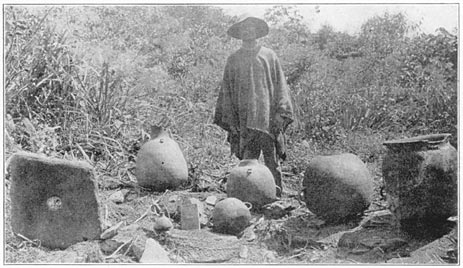
(Above: A Peruvian farmer with looted Inca artifacts in 1911; photo by Hiram Bingham)
Peruvian historian had already published maps of ancient Machu Picchu
June 6, 2008
EFE
(Translated by Kim MacQuarrie)
The Peruvian historian Mariana Mould de Pease published maps in 2003 showing that the famous Inca citadel of Machu Picchu was already known in ancient times and was sacked by the German adventurer Augusto Berns in 1867.
These maps and the history of Berns were made public in an exclusive report last Tuesday by the American cartographer Paolo Greer…
(more…)

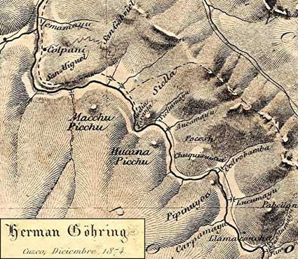
(At left: The American Paolo Greer discovered this map of the Machu Picchu area in Lima’s National Library. It was in an 1877 book by the German geologist, Herman Göhring. The map is dated 1874 and clearly indicates two peaks: “Macchu Picchu” and “Huaina Picchu,” although no accompanying ruins are indicated.)
Machu Picchu Before Bingham (Part 2)
By Paolo Greer
South American Explorer Magazine
Edition 87
June 2008
The Oldest Map of Machu Picchu
In 1989, I was granted an interview with Juan Mejía Baca, the Director of the National Library of Perú. I had spent many weeks in the library and had finally worked up my courage to make a few suggestions to Don Juan about how he might make his archives more accessible.
(more…)


