Was Machu Picchu “Discovered” & Looted 43 Years Before Hiram Bingham’s Arrival? (Part 1)
posted on June 21st, 2008 in Andes Mountains, Archaeology, Did a German Discover Machu Picchu?, Incas, Machu Picchu, Peru, Recent Discoveries
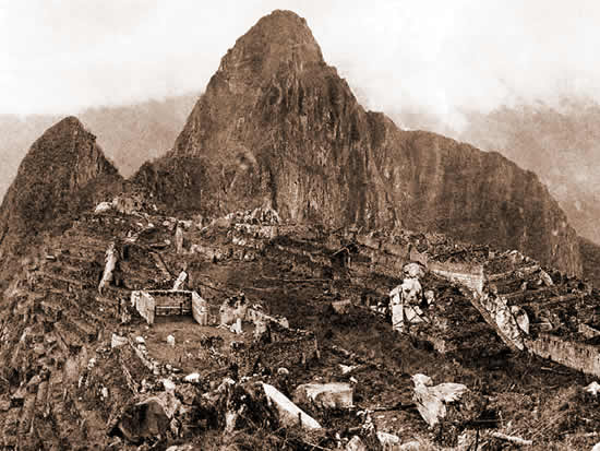
(Above: Machu Picchu in 1912; Photo by Hiram Bingham III)
Note: Recently there has surfaced in the press the announcement that a German adventurer/businessman, Augusto R. Berns, actually discovered Machu Picchu (and looted it with the permission of the Peruvian government at the time) some four decades before the American historian, Hiram Bingham, stumbled upon the ruins in 1911 and officially “discovered” them. The press reports promised that the man making this claim, the American Paolo Greer, would soon publish his proof in the “South American Explorer Magazine.” Greer’s article has just been published and Part I is reprinted in full below.
A few personal observations: Greer has presented a lot of interesting information. Without having seen the documents in question myself (some of which Greer says he has seen, but have since gone missing!?), it would seem nevertheless that the businessman in question, Augusto R Berns, not only did exist but that he indeed had permission from the Peruvian govt at the time (in the late 1800s) to loot Inca ruins,in the area of Machu Picchu, in return for a 10% cut of any precious metals found. Ironically, the conquistador Francisco Pizarro was burdened with a far worse contract: he had agreed with the Spanish crown that the crown would receive a 20% cut of everything looted in Peru, including precious metals, lands, crops, etc. Thus four centuries later, a German apparently cut a much more lucrative deal….
Regarding the “oldest map” of Machu Picchu, which I have also not seen, Greer states that it dates from 1874 and that it displays the peaks of Machu Picchu and Huayna Picchu on it. He also states that the book the map was contained in, published in 1877, refers to the “forts of Chuquillusca, Torontoy and Picchu,” the latter seemingly a clear reference to the ruins of Machu Picchu.
As I point out in “The Last Days of the Incas” (p 450), the great Italian geographer Antonio Raimondi published a map of Peru in 1865 on which he clearly denoted the peak of Machu Picchu, nine years before the map in question. In 1880, publishing the results of a voyage that he had taken to Peru in 1875, the Frenchman Charles Wiener also published a map, on which he clearly had the correct locations of the peaks “Matchopicchu” & “Huaynapicchu” on them. In addition, Wiener wrote that locals in the town of Ollantaytambo had told him about “still other [ancient Inca] towns, about Huaina-Picchu and about Matcho-Pitcho.” (Hiram Bingham, by the way, admitted that he had read Wiener’s book prior to his expedition in 1911 that resulted in the “discovery” of Machu Picchu, and that he also had Raimondi’s 1865 map with him. He gave neither credit for having helped him locate his discovery, however).
What seems to be clear is that, as has often been stated, Hiram Bingham was the “scientific discoverer” of Machu Picchu, meaning he was the first scientist or historian to visit the ruins, to photograph them, to map them, to (scientifically) excavate them, and to publish his discovery for all the world to see (initially in the pages of National Geographic; later in a series of books).
Bingham was clearly not the first to “discover” the ruins of Machu Picchu, however, as two Peruvian peasant familes already lived at the ruins, Bingham was taken there by a Peruvian guide who lived in the valley below, Bingham found graffiti on Machu Picchu’s walls, and a variety of other individuals in Cuzco and elsewhere had told Bingham that important Inca ruins were to be found in this location. The American Rector of Cuzco’s university at the time, Albert Giesecke, in fact, actually told Bingham where to go and which peasant could guide him there!
Was Augusto R Berns the actual “discoverer” of Machu Picchu then? It seems doubtful. This was the era of the beginning of the rubber boom in Peru, after all, when thousands were beginning to pour into Peru’s jungles searching for wild rubber trees from which to make their fortunes and looking in every nook and cranny. The rubber boom actually resulted in the Peruvian government blasting a road down the Vilcanota/Urubamba River past the ruins of Machu Picchu, sometime in the 1890s, a road that Hiram Bingham used to his advantage to make his eventual “discovery.” Locals during Berns’ time obviously knew about the ruins (since they told Wiener about them in 1875) as they did 40 years later during Bingham’s time, and they may very well have taken Berns there. Perhaps new discoveries of documents currently languishing in some archive somewhere will one day shed more light on this matter. –KM
Machu Picchu Before Bingham (Part 1)
By Paolo Greer
South American Explorer
Edition 87
June, 2008
In 1471, the year the Conquistador Francisco Pizarro was born, Pachacuti Yupanqui died. Pachacuti was the ninth Inca and Atahualpa’s Great Grandfather. When he wasyoung, Pachacuti was known simply as Cusi Yupanqui. Then, the Inca kingdom was small and their enemies, the Chancas, attacked their home, Cusco. Cusi’s Father, Viracocha, and his six brothers fled, while he, the youngest, stayed to successfully defend the city.
In the decades that followed, Cusi Yupanqui and his sons, Yamque and Topa, extended the Inca Empire to include vast territories and numerous civilizations. Cusi became known as “Pachacuti,” “He Who Changes the World”.
The “World Changer” confined Cusco’s rivers to stone channels and had his capital completely rebuilt. He created the Inca system of warehouses and roads, with chasqui messengers to maintain rapid communication. He defined the calendar, festivals, customs and laws for his people to follow and organized a warrior class for the conquests to come.
It was Pachacuti who ordered the holiest Inca site, the Sun Temple or Coricancha, to be constructed. For that, he gathered the best goldsmiths and told them to fashion a life-sized figure of a young boy, resembling the brilliantly shining child he had seen in a vision while protecting Cusco.
Pachacuti personally placed the finished statue in an interior room of the Coricancha, where only he, certain lords and special caretakers, were allowed to enter to revere the child’s figure, the most sacred icon in the realm. Like Pachacuti, the golden sculpture was considered a representative of the sun.
On the same day that Pachacuti installed the boy’s image in the Sun Temple, he had a sugarloaf shaped stone, an intihuatana or “sun hitch”, placed in the center of the principal plaza of Cusco. The specially carved rock represented the sun, for one and all to worship.
Although Pachacuti’s victories stretched throughout the Inca’s known world, his initial invasions were in the Urubamba Valley. It was there that the aged leader had a village built for his panaca or descendant family to care for his tomb and to serve his memory.
He called the town Patallacta, “High City.” It is now known as Machu Picchu.
The Inca History is Recorded
Huayna Capac, Pachacuti’s grandson, chose the newborn Cuxirimay (‘Speaks Good Fortune’) to eventually wed his son, Atahualpa. After Huayna Capac’s death, Cuxirimay was in Atahualpa’s camp when he was captured by Pizarro. She stayed with the imprisoned Inca leader until his execution by the Spaniards.
Following Atahualpa’s murder, Cuxirimay became Doña Angelina Yupanqui, and Francisco Pizarro’s mistress. She bore him two sons, Juan and Francisco. When Pizarro was assassinated in 1541, Angelina Yupanqui was nineteen years old.
In 1544, Doña Angelina became the wife of Juan de Betanzos, a Quechua interpreter for the Conquistadors. Following the conquest of Perú, Betanzos became the most respected translator for the Viceroyalty. In the same year that he wed Angelina, Betanzos was commissioned to write the Church’s religious conversion manuals and Spanish-Quechua dictionaries.
In 1551, the Viceroy Mendoza ordered Betanzos to record the history of the Incas. Betanzos’ unique work, Suma y narracion de los Yngas, was finished in 1557. However, all but the initial eighteen chapters were lost for more than 400 years.
In 1987, a complete manuscript, with an additional sixty-four chapters, was found in Palma de Mallorca, Spain. The “Inca Garcilaso” produced his “Royal Commentaries” in 1609, based mostly on what he remembered as a child before leaving Perú in 1560.
Bernabe Cobo, like Garcilaso, among the most cited of Inca authorities, relied on the scant records available in his day, publishing his history in 1653, nearly one hundred years after Betanzos’ direct translations from Atahualpa’s cousin-wife and their surviving relatives.
Perhaps, it was then that Cuxirimay, a.k.a. Doña Angelina Yupanqui, finally “spoke her good fortune” by preserving the history of her vanquished ancestors. Without the telling of her story by Juan de Betanzos, and his Narration’s recent rediscovery, much of the Inca’s own account might have been lost forever.
The Rediscovery of Patallacta
From Inca Land – Explorations in the Highlands of Peru (1912) by Hiram Bingham: “On the afternoon of July 23rd we reached a hut called “La Maquina,” where travelers frequently stop for the night. The name comes from the presence here of some large iron wheels, parts of a “machine” destined never to overcome the difficulties of being transported all the way to a sugar estate in the lower valley, and years ago left here to rust in the jungle….”
The rusted machine that the Yale explorer wrote about had nothing to do with sugar cane. It was a sawmill, brought to Perú before Bingham’s birth by a German, Augusto R. Berns, for the purpose of producing ties for the Southern Perú Railroad.
The site of La Maquina is now Aguas Calientes, the community just below Machu Picchu.
In 1867, Berns purchased twenty-five kilometers of the northern bank of the Urubamba/Vilcanota River, next to the famous citadel. His estate, the “Cercado de San Antonio” or “Torontoy,” extended above and far downriver from the present ruins of Torontoy, and up to the mountain crests, directly opposite of Machu Picchu. Even today, this region within plain sight of the best known ancient city in the Americas is virtually unknown.
Pre-Bingham Research
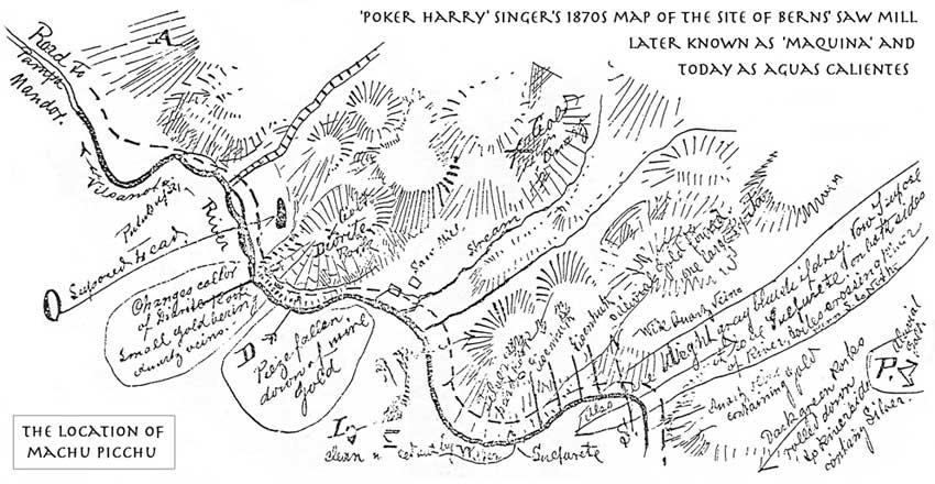
I first walked the popular Inca trail in 1974, several years before I encountered history of the area that pre-dated Hiram Bingham. Like many a good adventure, this one started with the serendipitous discovery of an old map. I came upon the sketch during one of my trips to the U.S. Library of Congress. It had no title or date, although it indicated the locations of mineral deposits along the Vilcanota River. Oddly, it was in English and in its center was a spot marked “Saw Mill”.
(Above: This map, discovered by Paolo Greer in 1978, was apparently made by ‘Poker’ Harry Singer, Augusto Berns’ partner. It shows supposed gold mining deposits, close to Aguas Calientes, where Berns’ had a sawmill operation)
It took me another twenty years to find out who had drawn the map and why.
That same year, in 1978, I found another clue, one that also took decades to comprehend. I had sent away for a large 900-page volume, the “Directory of Archives and Manuscript Repositories.” The index described hundreds of historical collections in the United States.
I read it carefully, page by page, gleaning any reference I could about Perú.
One brief citation mentioned “promotional materials relating to an attempt to exploit a mineral area of Perú, 1881.” It caught my eye because, in those years, my passion was exploration for long forgotten mines in the “Caravaya,” a remote section of high jungle in the department of Puno near the Bolivian frontier.
Alas, this particular prospect was somewhere else entirely, on the river Vilcanota near a place called Torontoy.
(Next: Part 2)


